Abstract: in the last ten years, unmanned aerial vehicles have gained immense popularity, especially in the most developed countries of the world. The scope of drones is quite wide.
This article analyzes the scope of drones with their advantages and disadvantages, as well as the prospects for the development of this area in Russia and especially in the Ulyanovsk region.
Key words: unmanned aerial vehicle, drone, drone, scope. An unmanned aerial vehicle is an aircraft without a crew on board. UAVs can have varying degrees of autonomy - from remotely controlled to fully automatic, and also differ in design, purpose and many other parameters.
In the last ten years, unmanned aerial vehicles have gained immense popularity, especially in the most developed countries of the world.
The scope of drones is quite wide. They can monitor the traffic situation, both urban and in remote areas, control the fire situation in forests or flood waters in the regions, and much more. On duty, the drones transmit footage to a laptop, which can be used to control the drone.
We present to your attention the areas of application of UAVs:
1) Spectrozonal survey
A type of photography, during which the simultaneous acquisition of photographic images of an object in different parts (zones) of the spectrum of electromagnetic waves takes place. For example, in agriculture The use of a UAV allows obtaining a terrain model with a resolution of up to 3 cm. Images are obtained in the visible and infrared ranges. Such a survey gives a comprehensive picture of the state of the soil, and the detail allows you to control crops with an accuracy of 5 cm. A wide range of data obtained allows you to evaluate field problems by seedlings and identify the causes of a wide variety of problems
2) Aerial photography of the area
This is a set of works that includes various processes from photographing the earth's surface from a flying aircraft to obtaining aerial photographs, photographic schemes or photographic plans of the area taken. All aerial photographic materials are used to solve a number of issues in the field of forestry and the forest industry.
In plan shooting, the camera is directed vertically down, at right angles to the ground. In the pictures we see a flat picture (orthogonal projection), reminiscent of an image on geographical maps.
In perspective (overview) shooting, the camera is directed at an angle to the horizon. With perspective aerial photography in the pictures we see a three-dimensional picture (axonometric projection): not only the roofs of structures, but also the side surfaces (walls).
Thus, we can judge not only the mutual arrangement of objects on the plane, but also their shape. 3) Accounting for animals from the air using UAVs With a significant reduction in the funds spent on attracting manned aircraft, the use of unmanned aerial vehicles for recording animals has become profitable.
Such an "air count" allows you to accurately determine the number of animals in the hunting area and identify the places of their concentration. 4) Remote monitoring of the condition of oil and gas pipelines To date, the use of unmanned aerial vehicles is the most effective and cost-effective method of inspecting oil and gas pipelines.
High-quality images are obtained in real time, which allow detecting oil spills, identifying acts of unauthorized activity (landfills, tie-ins, work in protected areas, etc.).
Aerial photographs obtained from the UAV board allow analyzing and evaluating the technical condition of pipelines and the near-pipe space.
5) Aerial and space survey of the area It is used both for continuous simultaneous monitoring of pollution of the natural environment (the earth's surface, water areas and the surface atmosphere), and for monitoring the technical condition of objects throughout the thousand-kilometer water and land oil and gas routes.
In addition, remote monitoring data makes it possible to quickly identify and accurately determine the coordinates of zones of dangerous manifestation of natural processes that can lead to accidents, as well as to track and predict slow unidirectional geodynamic deformations of the earth's surface that are fraught with ruptures of main pipelines.
Among the main tasks solved with the help of aerial and space photography, the following can be distinguished: identification of violations of the technical condition of the object: gaps, cracks, corrosion zones, damage to hydro- and thermal insulation, etc.; drawing up maps of soils, flood zones, flooded areas, areas of salinization, freezing and thawing soils, etc.; study of modern exogenous processes (mudflows, landslides, landslides, etc.).
6) Aerial photography and geodesy
Provides aerial photography materials that can be used in the following areas of activity: maintenance of the state real estate cadastre and control of urban planning activities in settlements; emergency response; control of snow and ice cover, ice cover, forecast of river runoff and monitoring of river floods; updating topographic maps; monitoring various types objects; monitoring of the state of agricultural land, including the intended use of land, operational assessment of the state and degree of land degradation, yield forecast; Creation of geographic information systems.
7) Monitoring and identification of moving objects
Monitoring is carried out in protected areas during the day and at night.
Monitoring of forest resources
It includes an assessment of the degree of deforestation, identification of tree species, prevention of forest fires (dried forest, smoldering peat bogs, detection of small fires), assessment of damage to forest resources after fires or natural disasters, detection of unauthorized dumps, with the identification of violators' faces and car numbers. Drones with infrared sensors are used to detect forest fires at an early stage.
9) Monitoring of repair and construction works
It speeds up and reduces the cost of work many times over compared to traditional methods. It allows you to assess the degree of readiness of the object; identify and analyze damage, accidents; to plan repair work; predict and model natural impacts.
10) Unmanned security
Increases the level of security by controlling objects and people in certain areas. Most of the time the security guard spends on patrolling the territory of the enterprise, and the drone does it much faster and better.
There are many examples of this: to avoid unauthorized intrusions, drones patrol oil and gas pipelines, mineral deposits, power lines from the removal of insulators, cities and intercity highways during large-scale events. In order to ensure the safety of facilities, drones guard the Baikonur Cosmodrome and the FIFA 2018 facilities under construction for the World Cup.
11) Unmanned border guards
They observe the border with the help of infrared and conventional video cameras from a height of up to 6 km with an overview of 50 km. The image from the video camera is so detailed that from a height you can see what is behind the shoulders of the violators.
12) Police SWAT
These are unmanned microdrones that can be launched directly from the hands. They fly at an altitude of up to 75 m, their electric motor is practically inaudible from the ground and is able to keep the device in the air for more than an hour.
Such drones are the forerunners of the development of a branch of subminiature devices - so tiny that the very concept of an aircraft in relation to them will require some clarification. Drones weighing only 10 grams have now been developed. 13) UAV for delivering goods to customers The drone delivery system has been launched in test mode in the American online store Amazon, as well as in postal service Switzerland. These drones are capable of transporting loads weighing up to 1 kg for a distance exceeding 10 km without recharging the battery. Also, projects began to work on round-the-clock delivery of medicines, groceries, as well as on the return of goods that did not fit.
14) Help in Emergencies
Drone to find missing children - like dogs, can track the smell of a child. Drones with temperature sensors are being used to search for people littered with an avalanche.
15) Waiter Drones
Eateries have sprung up in Europe and Asia that have become famous for using drones to deliver orders to tables: a flat-top quadcopter controlled by a waiter with an iPad can bring food and drinks to customers at a speed of 40 km/h. But what is done in the UK to attract attention, in Singapore - a severe necessity.
There are a lot of restaurants here, and the staff for them is becoming a scarce workforce, so local restaurateurs are hard at work experimenting with technologies that could solve the problem - from rice frying machines to mini trains for delivering orders. Drones were a logical next step, and since February of this year, the Timbre restaurant chain has introduced them to the staff: diners order using a tablet computer mounted on the table, and food and drinks arrive from the kitchen on a quadcopter.
16) Internet Sharing Drone
Two giants of the IT industry, Google and Facebook, almost simultaneously announced their plans to create a network of satellites and drones that form Internet coverage over the entire surface of the earth.
17) Beach lifeguard
A drone is a great analogue of a lifeguard sitting on a tower. This was proved in Australia: the local service successfully tested a multicopter configured to monitor the coastal zone. The device not only can warn bathers about the approach of sharks - if necessary, it is able to throw a life buoy to a drowning person. After analyzing all of the above, we can conclude that in the very near future, unmanned aircraft will take the first and most important place compared to manned aircraft.
This can be explained by the fact that the use of drones does not require human resources, and therefore no one endangers their lives, and also by the fact that drones have a very wide range of applications in the defense industry, security, healthcare, entertainment and many other areas. The Ulyanovsk region may well become a pioneer in the creation of drones, using all the competencies developed by the region.
Communications and communications, remote sensing of the earth and monitoring, search and rescue of people, agriculture and transportation are considered as priority segments of this market.
Unmanned aircraft systems in these niches are in demand and have good prospects. According to the official resource of the regional government, plans have already been outlined to create a structure in the region that will create the latest aircraft and integrate the capabilities that the nanocenter and the largest industrial complex Russia "Aviastar-SP". In the Ulyanovsk region, it is planned to develop a "Road Map", which will prescribe the scope of unmanned aerial vehicles.
Thus, we can say that unmanned vehicles (both flying and non-flying) are the future.
References 1. Unmanned aerial vehicles / Help Guide. Voronezh, Publishing House Polygraphic Center "Scientific Book", 2015. 616 p. pp. 43-56. 2. Vasilin N.Ya. Unmanned aerial vehicles // N.Ya. Vasilin. Minsk. Potpourri, 2017. 272 p. C. 5-7, 98-105. ISBN: 9854389839. 3. Bodrova A.S., Bezdenezhnykh S.I. // Prospects for the development and use of complexes with unmanned aerial vehicles: conf. Kolomna, 2016. 274 p. pp. 106-113. 4. Boyko A. // Areas of application of drones. [ Electronic resource]. Access mode: http://robotrends.ru/robopedia/oblasti-primeneniya-bespilotniko/ (date of access: 10/25/2017).
Fedoseeva N.A. , Zagvozkin M.V.
ATTENTION: You are viewing the text part of the content of the abstract, the material is available by clicking the Download button
Tactical and technical characteristics of unmanned aerial vehicles in service with units of the constituent entity of the Russian Federation
For the technical equipment of the Ministry of Emergency Situations of Russia with unmanned aerial vehicles, Russian enterprises Several options have been developed, consider some of them:
UAV ZALA 421-16E
- this is a long-range unmanned aircraft (Fig. 1.) with an automatic control system (autopilot), a navigation system with inertial correction (GPS / GLONASS), an integrated digital telemetry system, navigation lights, a built-in three-axis magnetometer, a target retention and active tracking module ( "AC Module"), a digital built-in camera, a digital wideband video transmitter of C-OFDM modulation, a radio modem with a satellite navigation system (SNS) receiver "Diagonal AIR" with the ability to work without a SNS signal (radio range finder) a self-diagnostic system, a humidity sensor, a temperature sensor, a current sensor, a propulsion system temperature sensor, a parachute release, an air cushion to protect the target load during landing, and a search transmitter.
This complex is designed for conducting aerial surveillance at any time of the day at a distance of up to 50 km with real-time video transmission. The unmanned aircraft successfully solves the tasks of ensuring the security and control of strategically important objects, allows you to determine the coordinates of the target and quickly make decisions on adjusting the actions of ground services. Thanks to the built-in AS Module, the UAV automatically monitors static and moving objects. In the absence of a SNS signal, the UAV will autonomously continue the task
Figure 1 – UAV ZALA 421-16E
UAV ZALA 421-08M
(Fig. 2.) Made according to the "flying wing" scheme - this is a tactical range unmanned aircraft with an autopilot, it has a similar set of functions and modules as ZALA 421-16E. This complex is designed for operational reconnaissance of the area at a distance of up to 15 km with real-time video transmission. UAV ZALA 421-08M compares favorably with ultra-reliability, ease of use, low acoustic, visual visibility and the best target loads in its class. This aircraft does not require a specially prepared runway due to the fact that the takeoff is made by means of an elastic catapult, it carries out aerial reconnaissance under various weather conditions at any time of the day.
Transportation of the complex with UAV ZALA 421-08M to the place of operation can be carried out by one person. The lightness of the device allows (with appropriate training) to launch "by hand", without using a catapult, which makes it indispensable in solving problems. The built-in AS Module allows the unmanned aircraft to automatically monitor static and moving objects, both on land and on water.

Figure 2 – UAV ZALA 421-08M
UAV ZALA 421-22
is an unmanned helicopter with eight rotors, medium range, with an integrated autopilot system (Fig. 3). The design of the apparatus is foldable, made of composite materials, which ensures the convenience of delivery of the complex to the place of operation by any vehicle. This device does not require a specially prepared runway due to vertical automatic launch and landing, which makes it indispensable for aerial reconnaissance in hard-to-reach areas.
ZALA 421-22 is successfully used to perform operations at any time of the day: to search and detect objects, to ensure the security of perimeters within a radius of up to 5 km. Thanks to the built-in “AS Module”, the device automatically monitors static and moving objects.

Phantom 3 Professional
It represents the next generation of DJI quadcopters. It is capable of recording 4K video and transmitting high definition video right out of the box. The camera is integrated into the gimbal for maximum stability and weight efficiency when minimum size. In the absence of a GPS signal, the Visual Positioning technology ensures hovering accuracy.
Main functions
Camera and Gimbal: The Phantom 3 Professional shoots 4K video at up to 30 frames per second and captures 12 megapixel photos that look sharper and cleaner than ever. The improved camera sensor gives you greater clarity, lower noise, and better shots than any previous flying camera.
HD Video Link: Low latency, HD video transmission based on the DJI Lightbridge system.
DJI Intelligent Flight Battery: 4480 mAh DJI Intelligent Flight Battery has new elements and uses intellectual system battery management.
Flight Controller: Next-generation flight controller for more reliable performance. The new recorder saves the data of each flight, and visual positioning allows you to accurately hover at one point in the absence of GPS.

Figure 4 - Phantom 3 Professional UAV
UAV Inspire 1
The Inspire 1 is a new multi-rotor capable of recording 4K video and transmitting HD video (up to 2 km) to multiple devices right out of the box. Equipped with a retractable landing gear, the camera can rotate 360 degrees unhindered. The camera is integrated into the gimbal for maximum stability and weight efficiency in a minimal footprint. In the absence of a GPS signal, the Visual Positioning technology ensures hovering accuracy.
Main functions
Camera & Gimbal: Records up to 4K video and 12-megapixel photos. Neutral density (ND) filters are provided for better exposure control. The new gimbal mechanism allows you to quickly remove the camera.
HD Video Link: Low latency, HD video transmission, this is an upgraded version of the DJI Lightbridge system. There is also the possibility of control from two remote controls.
Chassis: Retractable landing gear, allows the camera to take panoramas unhindered.
DJI Intelligent Flight Battery: 4500mAh uses an intelligent battery management system.
Flight Controller: Next-generation flight controller for more reliable performance. The new recorder saves the data of each flight, and visual positioning allows, in the absence of GPS, to accurately hover at one point.

Figure 5 - UAV Inspire 1
All characteristics of the UAVs listed above are presented in Table 1 (except for Phantom 3 Professional and Inspire 1 as indicated in the text)
Table 1. Characteristics of the UAV
| UAV | ZALA 421-16E | ZALA 421-16EM | ZALA 421-08M | ZALA 421-08F | ZALA 421-16 | ZALA 421-04M |
| UAV wingspan, mm | 2815 | 1810 | 810 | 425 | 1680 | 1615 |
| Flight duration, h (min) | >4 | 2,5 | (80) | (80) | 4-8 | 1,5 |
| UAV length, mm | 1020 | 900 | 425 | – | – | 635 |
| Speed, km/h | 65-110 | 65-110 | 65-130 | 65-120 | 130-200 | 65-100 |
| Maximum flight altitude, m | 3600 | 3600 | 3600 | 3000 | 3000 | – |
| Target load mass, kg (g) | Up to 1.5 | Up to 1 | (300) | (300) | – | Up to 1 |
Lesson on solving problems, taking into account the capabilities of unmanned aerial vehicles that are in service with the units of the subject of the Russian Federation.
– detection of emergencies;
- participation in the liquidation of emergency situations;
– assessment of damage from emergencies.
Considering the experience of using unmanned aerial vehicles in the interests of the Russian Emergencies Ministry, the following generalizations can be made: - the economic feasibility of using unmanned aerial vehicles is due to ease of use, the possibility of takeoff and landing on any selected territory; - the operational headquarters receives reliable video and photo information, which allows you to effectively manage the forces and means of localization and liquidation of emergencies; - the possibility of transmitting video and photo information in real time to control points allows you to quickly influence a change in the situation and make the right management decision; – the possibility of manual and automatic use of unmanned aerial vehicles. In accordance with the Regulations "On the Ministry of the Russian Federation for Civil Defense, Emergency Situations and Elimination of Consequences of Natural Disasters", the EMERCOM of Russia manages the Unified state system prevention and liquidation of emergency situations. The efficiency of such a system is largely determined by the level of its technical equipment and proper organization the interactions of all its constituent elements. To solve the problem of collecting and processing information in the field of civil defense, protecting the population and territories from emergencies, ensuring fire safety, the safety of people in water bodies, as well as exchanging this information, it is advisable to use technical means space, air, ground or surface-based. The time factor is extremely important when planning and carrying out measures to protect the population and territories from emergencies, as well as ensuring fire safety. From timely receipt of information about emergencies to management
The use of unmanned aerial vehicles in the interests of the Russian Emergencies Ministry is very relevant. Unmanned aerial vehicles are experiencing a real boom. Unmanned aerial vehicles of various purposes, various aerodynamic schemes and with a variety of tactical and technical characteristics rise into the airspace of various countries. The success of their application is associated, first of all, with the rapid development of microprocessor computing, control systems, navigation, information transmission, and artificial intelligence. Achievements in this area make it possible to fly in automatic mode from takeoff to landing, to solve the problems of monitoring the earth's (water) surface, and for military unmanned aerial vehicles to provide reconnaissance, search, selection and destruction of targets in difficult conditions. Therefore, in most industrialized countries, both the aircraft themselves and the power plants for them are being developed on a wide front.
Currently, unmanned aerial vehicles are widely used by the Russian Medical Unit for managing crisis situations and obtaining operational information.
They are able to replace aircraft and helicopters in the course of performing missions that risk the lives of their crews and possible loss expensive manned aircraft. The first unmanned aerial vehicles were delivered to the EMERCOM of Russia in 2009. In the summer of 2010, unmanned aerial vehicles were used to monitor the fire situation in the Moscow region, in particular, in the Shatursky and Egoryevsky districts. In accordance with Decree of the Government of the Russian Federation of March 11, 2010 No. 138 “On Approval of the Federal Rules for the Use of the Airspace of the Russian Federation”, an unmanned aerial vehicle is understood to be an aircraft that flies without a pilot (crew) on board and is automatically controlled in flight by an operator from the control point or a combination of these methods
The unmanned aerial vehicle is designed to solve the following tasks:
– unmanned remote monitoring of forest areas in order to detect forest fires;
– monitoring and transmission of data on radioactive and chemical contamination of terrain and airspace in a given area;
engineering reconnaissance of areas of floods, earthquakes and other natural disasters;
– detection and monitoring of ice jams and river floods;
– monitoring of the state of transport highways, oil and gas pipelines, power lines and other facilities;
– ecological monitoring of water areas and coastline;
- determination of the exact coordinates of emergency areas and affected objects.
Monitoring is carried out day and night, in favorable and limited weather conditions.
Along with this, the unmanned aerial vehicle ensures the search for technical equipment that has crashed (accident) and missing groups of people. The search is carried out according to a pre-set flight task or along a flight route that is quickly changed by the operator. It is equipped with guidance systems, airborne radar systems, sensors and cameras.
During the flight, as a rule, the control of an unmanned aerial vehicle is automatically carried out by means of an onboard navigation and control complex, which includes:
- a satellite navigation receiver that provides reception of navigation information from GLONASS and GPS systems;
- a system of inertial sensors that determines the orientation and motion parameters of an unmanned aerial vehicle;
- a system of sensors that provides measurement of altitude and airspeed;
– different kinds antennas. The on-board communication system operates in the authorized radio frequency range and provides data transmission from board to ground and from ground to board.
Tasks for the use of unmanned aerial vehicles can be classified into four main groups:
– detection of emergencies;
- participation in the liquidation of emergency situations;
– search and rescue of victims;
– assessment of damage from emergencies.
The detection of an emergency is understood as a reliable establishment of the fact of an emergency, as well as the time and exact coordinates of the place of its observation. Aerial monitoring of territories using unmanned aerial vehicles is carried out on the basis of forecasts of an increased probability of an emergency or according to signals from other independent sources. This may be a flight over forest areas in fire hazardous weather conditions. Depending on the speed of the emergency, data is transmitted in real time or processed after the return of the unmanned aerial vehicle. The received data can be transmitted via communication channels (including satellite) to the headquarters of the search and rescue operation, the regional center of the EMERCOM of Russia or the central office of the EMERCOM of Russia. Unmanned aerial vehicles can be included in the forces and means to eliminate emergencies, and can also be extremely useful, and sometimes indispensable, when conducting search and rescue operations on land and at sea. Unmanned aerial vehicles are also used to assess damage from emergencies in cases where this must be done promptly and accurately, as well as without risk to the health and life of ground rescue teams. Thus, in 2013, unmanned aerial vehicles were used by employees of the Russian Emergencies Ministry to monitor the flood situation in the Khabarovsk Territory. With the help of data transmitted in real time, the state of protective structures was monitored to prevent dam breaks, as well as the search for people in flooded areas with subsequent adjustment of the actions of employees of the Russian Emergencies Ministry.
Considering the experience of using unmanned aerial vehicles in the interests of the Russian Emergencies Ministry, the following generalizations can be made: - the economic feasibility of using unmanned aerial vehicles is due to ease of use, the possibility of takeoff and landing on any selected territory; - the operational headquarters receives reliable video and photo information, which allows you to effectively manage the forces and means of localization and liquidation of emergencies; - the possibility of transmitting video and photo information in real time to control points allows you to quickly influence a change in the situation and make the right management decision; – the possibility of manual and automatic use of unmanned aerial vehicles. In accordance with the Regulations "On the Ministry of the Russian Federation for Civil Defense, Emergency Situations and Elimination of Consequences of Natural Disasters", the Russian Emergencies Ministry manages the Unified State System for the Prevention and Elimination of Emergency Situations at the federal level. The efficiency of such a system is largely determined by the level of its technical equipment and the correct organization of the interaction of all its constituent elements. To solve the problem of collecting and processing information in the field of civil defense, protecting the population and territories from emergencies, ensuring fire safety, the safety of people in water bodies, as well as exchanging this information, it is advisable to use complex space, air, ground or surface-based technical means. The time factor is extremely important when planning and carrying out measures to protect the population and territories from emergencies, as well as ensuring fire safety. The level of economic damage from emergencies and the number of affected citizens largely depend on the timely receipt of information about emergencies by the leadership of the Ministry of Emergency Situations of Russia at various levels and on the prompt response to what is happening. At the same time, in order to adopt appropriate operational management decisions it is necessary to provide complete, objective and reliable information, not distorted or modified due to subjective factors. Thus, the further introduction of unmanned aerial vehicles will significantly contribute to filling information gaps regarding the dynamics of the development of emergencies. Extremely important task is to detect the occurrence of an emergency. The use of unmanned aerial vehicles alone can be very effective for a slowly developing emergency or emergency in relative proximity to the deployed forces and means to eliminate it. At the same time, in combination with data obtained from other technical means of space, ground or surface-based, the real picture of upcoming events, as well as the nature and pace of their development, can be presented in detail. The technical equipment of the EMERCOM of Russia with promising robotic systems is an urgent and extremely important task. The development, production and implementation of such tools is a rather complex and capital-intensive process. However, government spending on such equipment will be covered by the economic effect of the prevention and elimination of emergencies using this equipment. Only from the annual forest fires, the Russian Federation suffers colossal economic losses. Thus, in order to modernize the technical base of the EMERCOM of Russia, a Program was developed to re-equip the units of the EMERCOM of Russia with modern models of machinery and equipment for 2011-2015. Analysis of the response of authorities and forces to federal emergencies associated with the passage of the summer-autumn flood of 2013 in the Far East federal district, emphasized the relevance of the use of unmanned aerial vehicles in the interests of the Russian Emergencies Ministry. In connection with this, it was decided to create a division of unmanned aerial vehicles. Along with this, there is whole line problems that need to be addressed before unmanned aircraft become widespread. Among them, one can single out the integration of unmanned aerial vehicles into the air traffic system in such a way that they do not pose a threat of collisions with manned aircraft, both civil and military. When conducting specific rescue operations, the forces of the Russian Emergencies Ministry have the right to use their technical means to carry out the necessary work. In this regard, there are currently no strict regulatory restrictions, and even more so, prohibitions on the use of unmanned aerial vehicles in the interests of the Russian Emergencies Ministry. However, regulatory issues legal regulation The development, production and use of unmanned aerial vehicles for civil use as a whole have not yet been resolved.
– the first turning point of the route (the starting point of the route (IPM) is set near the starting point.
- the depth of the working area should be within the limits of stable reception of the video signal and telemetry information from the UAV. (Depth of working area
– distance from the location of the NSS antenna to the most remote turning point. Working area - the territory within which the UAV performs a given flight program.).
– The track line, if possible, should not pass near power lines (power lines) of high power and other objects with a high level of electromagnetic radiation (radar stations, transceiver antennas, etc.).
— The estimated flight duration time must not exceed 2/3 of the maximum duration declared by the manufacturer.
- It is necessary to provide at least 10 minutes of flight time for take-off and landing. For general inspection territory, the most appropriate is a circular closed route. The main advantages of this method are the coverage of a large area, the efficiency and speed of monitoring, the possibility of surveying hard-to-reach areas of the terrain, relatively simple planning of a flight task, and prompt processing of the results obtained. The flight route must provide an inspection of the entire working area.
For the rational use of UAV energy resources, it is advisable to lay the flight route in such a way that the first half of the UAV flight takes place against the wind.

Figure 1 - Building a flight route, taking into account the wind.
For a detailed inspection of individual sections of the terrain within the working area, rectilinear mutually parallel routes are used.

Figure 2 - Building a flight of a straight parallel route.
The parallel route is recommended for use in aerial photography of terrain. When preparing a route, the operator must take into account the maximum width of the field of view of the UAV camera at a given altitude of its flight. The route is laid so that the edges of the camera's field of view overlap neighboring fields by about 15% -20%.

Figure 3 - Parallel route.
Flight over a given object is used when conducting inspections of specific objects. It is widely used in cases where the coordinates of an object are known and its state needs to be clarified.
Figure 4 - Flyby of a given object
During the inspection of active forest fires, the operator determines the main direction of the spread of fire, the presence of a threat of fire spread to economic facilities and settlements, the presence of separate combustion centers, areas that are especially dangerous in terms of fire, the place where the fire passes through the mineralized strips, and, if possible, identifies the location of people and equipment employed in extinguishing a fire in order to determine the correctness of their placement on the edge of the fire. Simultaneously with the receipt of video information, representatives of the forestry service make decisions on tactical methods of extinguishing, maneuvering human and technical resources. Natural boundaries are outlined to stop the fire, access roads (approaches) to the fire, a section of the edge (roads, trails, lakes, streams, rivers, bridges).
UAV application example
In April 2011, three HE300 unmanned helicopters were used to visually monitor the stricken nuclear plant in Fukushima. These UAVs are equipped with a professional video camera, a thermal imaging camera, various sensors for measuring and shooting, and a tank for spraying various liquids. The results of video filming from the UAV are shown in Figure 5.6.

Figure 5.6 - Japanese nuclear power plant after an accident with a UAV.
In February 2014, ZALA UAVs allowed the Ministry of Emergency Situations in the Kirov region to control the situation during a fire on railway station(derailed and the composition with gas condensate caught fire), competently concentrate forces for the safe evacuation of residents and liquidation of the consequences of the incident. Aerial monitoring of the emergency zone was carried out in the daytime and at night, completely eliminating the risk to the life of the population and the emergency rescue team. Photos from the place. crashes filmed by the UAV are shown in Figure 7.

Support the project
There is an opinion that they have only a military purpose. In Russia, until recently, only the army had the opportunity to use UAVs. The drones performed the tasks of aerial photography (photo, video), radio reconnaissance, object detection, etc.
However, today the field of development and creation of unmanned systems has gone far beyond these limits. Currently, Russian UAVs are used in five civilian areas in addition to the military-industrial complex. Namely: emergency situations (search for people, emergency prevention, rescue operations, etc.); security (protection of objects and people, as well as their detection); monitoring (NPP, power lines, land, forestry, oil and gas, water resources, agriculture, etc.); aerial photography (geodesy, cartography, aerial survey); science (Arctic research, equipment research, R&D).
Types of drones
Now in production unmanned aerial vehicles more than 20 domestic enterprises are engaged in, producing about 50 models for various purposes. True, not all of these companies carry out a full cycle: from development to production. Most perform only screwdriver assembly of imported devices.
All UAVs are divided into 3 main types according to their type and scope of tasks: unmanned aircraft, unmanned helicopters and unmanned balloons. .jpg)
Unmanned aircraft
Drones of this type are used primarily for monitoring areal and linear areas of the terrain. They are able to overcome long distances, performing the most difficult aerial photography online at any time of the day and under any weather conditions. The maximum quality of work and efficiency of the tasks performed are possible at a distance of no more than 70 km from the ground control station. Speed - up to 400 km / h. Time spent in flight: from 30 minutes to 8 hours.
Unmanned helicopters
Machines of this type are used for operational monitoring of local areas of the terrain. They are small and easy to manage. They do not require a special runway. Like airplanes, unmanned helicopters can operate at any time of the day or night and in all weather conditions. Flight time: 30 minutes to 3 hours.
Unmanned balloons
Modern highly efficient devices designed for reconnaissance and surveillance of terrain at an altitude of up to 400 m. Lightweight, reliable, mobile vehicles capable of operating in real time for a long time.
Overview of manufacturers and models of drones
As mentioned above, UAV development companies in total number there are not many domestic producers. However, it is better to order the device from this minority. After all, they will not only design a car specifically for your requirements, but also equip it with everything necessary equipment, as well as select the best option for its management.
Today, such companies include: Yakovlev Design Bureau, MiG Design Bureau, Sukhoi Design Bureau, Sokol Design Bureau, Transas (all for military-industrial purposes); ZALA AERO GROUP, BLASKOR, Unmanned, Aerocon (all civil purposes), etc.
Price drone an average of about 500 thousand rubles. True, this is only the price of the drone model itself. The final amount depends on what the management complex will be. And they, depending on the tasks, are based on cars, boats, as well as ground, portable and mobile. Therefore, the total cost can reach several tens of millions of rubles.
.jpg) Currently, one of the most sought after drones is radio-controlled "Seraphim", created by the leading Russian company in the field of ZALA AERO UAVs. This is a "six-copter", that is, a 6-rotor helicopter. Widely used by the traffic police of Russia to search for stolen cars. Controlled by computer and GPS systems. Weighs only 1.2 kg and is easy to start with your hand. The electric charge is enough for a half-hour flight, but this is quite enough for the most powerful optics of the device to easily recognize the desired object at a distance of up to 5 km and from a height of up to 500 m.
Currently, one of the most sought after drones is radio-controlled "Seraphim", created by the leading Russian company in the field of ZALA AERO UAVs. This is a "six-copter", that is, a 6-rotor helicopter. Widely used by the traffic police of Russia to search for stolen cars. Controlled by computer and GPS systems. Weighs only 1.2 kg and is easy to start with your hand. The electric charge is enough for a half-hour flight, but this is quite enough for the most powerful optics of the device to easily recognize the desired object at a distance of up to 5 km and from a height of up to 500 m.
Another unmanned complex Supercam 100, developed by the domestic company Unmanned, is called a superplane. This is a versatile small-sized machine, always ready to start in any climatic conditions. The main purpose is remote monitoring, aerial photography of the relief, water surface, search and detection of objects. At the request of the customer, it is equipped with a video camera, a photo camera, a thermal imager. Starts from .jpg) using an elastic catapult. Landing is by parachute. Thanks to a special remote control, it is possible to combine up to 4 drones into one control system. Additionally, there is protection against loss of control. Flight range - 100 km, altitude - 3600 m, speed - 125 km / h.
using an elastic catapult. Landing is by parachute. Thanks to a special remote control, it is possible to combine up to 4 drones into one control system. Additionally, there is protection against loss of control. Flight range - 100 km, altitude - 3600 m, speed - 125 km / h.
In cramped urban conditions, it is inconvenient to use large high-speed unmanned aerial vehicles. Therefore, Aerocon has developed one of the lightest in the world (0.25 kg) mini-UAV "Inspector-101" for air .jpg) intelligence. This model is small in every way. It is equipped with a small-sized color video camera, a small screw that drives a tiny electric motor, and is controlled from the ground by a laptop computer. The launch is made from a catapult, landing - on the "belly". Able to work in a very wide temperature range: from -30 to +50 °C. Flight range - 44 km, speed - 72 km / h.
intelligence. This model is small in every way. It is equipped with a small-sized color video camera, a small screw that drives a tiny electric motor, and is controlled from the ground by a laptop computer. The launch is made from a catapult, landing - on the "belly". Able to work in a very wide temperature range: from -30 to +50 °C. Flight range - 44 km, speed - 72 km / h.
And again we return to the leading domestic developer and manufacturer of UAVs ZARA AERO GROUP. In addition to mobile devices of helicopter and aircraft type, the company is engaged in the production of the best unmanned aerial vehicles in Russia. .jpg) balloons. For example, a multifunctional, but easy-to-manage device. It is designed to perform a very wide range of tasks: monitoring of crowded places, reconnaissance, environmental measurements, emergency management, etc. It works autonomously up to 72 hours at wind speeds up to 15 m/s. Observation area coverage - 360°. The maximum deployment height is 300 m.
balloons. For example, a multifunctional, but easy-to-manage device. It is designed to perform a very wide range of tasks: monitoring of crowded places, reconnaissance, environmental measurements, emergency management, etc. It works autonomously up to 72 hours at wind speeds up to 15 m/s. Observation area coverage - 360°. The maximum deployment height is 300 m.
IN last years a large number of publications have appeared on the use of unmanned aerial vehicles (UAVs) or unmanned aerial systems (UAS) for solving topographic problems. Such interest is largely due to their ease of operation, efficiency, relatively low cost, efficiency, etc. The listed qualities and the availability of effective software tools automatic processing of aerial photography materials (including the selection of necessary points) open up opportunities for the wide use of unmanned aircraft software and hardware in the practice of engineering and geodetic surveys.
In this issue, with an overview of the technical means of unmanned aircraft, we open a series of publications on the capabilities of UAVs and the experience of their use in field and cameral work.
D.P. INOZEMTSEV, Project Manager, PLAZ LLC, Moscow Saint Petersburg
UNMANNED AERIAL VEHICLES: THEORY AND PRACTICE
Part 1. Overview of technical means
HISTORICAL REFERENCE
Unmanned aerial vehicles appeared in connection with the need to effectively solve military tasks - tactical reconnaissance, delivery of military weapons (bombs, torpedoes, etc.) to their destination, combat control, etc. And it is no coincidence that their first use is considered to be the delivery of bombs by the Austrian troops to the besieged Venice with balloons in 1849. A powerful impetus to the development of UAVs was the emergence of radiotelegraphy and aviation, which made it possible to significantly improve their autonomy and controllability.
So, in 1898, Nikola Tesla developed and demonstrated a miniature radio-controlled ship, and already in 1910, the American military engineer Charles Kettering proposed, built and tested several models of unmanned aerial vehicles. In 1933, the first UAV was developed in the UK.
reusable, and the radio-controlled target created on its basis was used in the Royal Navy of Great Britain until 1943.
For several decades ahead of their time, the research of German scientists, who gave the world in the 1940s jet engine and the V-1 cruise missile as the first unmanned aerial vehicle used in real combat operations.
In the USSR, in the 1930s–1940s, aircraft designer Nikitin developed a torpedo bomber-glider of the “flying wing” type, and by the beginning of the 40s, a project for an unmanned flying torpedo with a flight range of 100 kilometers and more was prepared, however, these developments did not turn into real designs.
After the end of the Great Patriotic War Interest in UAVs has increased significantly, and since the 1960s, they have been widely used to solve non-military tasks.
In general, the history of the UAV can be divided into four time periods:
1.1849 - the beginning of the twentieth century - attempts and experimental experiments to create a UAV, the formation theoretical foundations aerodynamics, flight theory and aircraft calculation in the works of scientists.
2. The beginning of the twentieth century - 1945 - the development of UAVs for military purposes (aircraft-projectiles with a short range and flight duration).
3.1945–1960 - the period of expanding the classification of UAVs for their intended purpose and creating them mainly for reconnaissance operations.
4.1960 years - today - the expansion of the classification and improvement of the UAV, the beginning of mass use for solving non-military problems.
UAV CLASSIFICATION
It is well known that aerial photography, as a type of remote sensing of the Earth (ERS), is the most productive method for collecting spatial information, the basis for creating topographic plans and maps, creating three-dimensional relief and terrain models. Aerial photography is carried out both from manned aircraft - airplanes, airships, motor hang gliders and balloons, and from unmanned aerial vehicles (UAVs).
Unmanned aerial vehicles, like manned ones, are of aircraft and helicopter type (helicopters and multicopters are aircraft with four or more rotors with rotors). At present, there is no generally accepted classification of aircraft-type UAVs in Russia. Missiles.
Ru together with the portal UAV.RU offers modern classification Aircraft-type UAV developed based on the approaches of UAV International, but taking into account the specifics and situation of the domestic market (classes) (Table 1):
Short range micro and mini UAVs. The class of miniature ultralight and light vehicles and complexes based on them with a takeoff weight of up to 5 kilograms began to appear in Russia relatively recently, but already quite
widely presented. Such UAVs are designed for individual operational use at short ranges at a distance of up to 25–40 kilometers. They are easy to operate and transport, are foldable and are positioned as "wearable", the launch is carried out using a catapult or by hand. These include: Geoscan 101, Geoscan 201, 101ZALA 421-11, ZALA 421-08, ZALA 421-12, T23 Eleron, T25, Eleron-3, Gamayun-3, Irkut-2M, " Istra-10",
"BRAT", "Lokon", "Inspector 101", "Inspector 201", "Inspector 301", etc.
Light short-range UAVs. This class includes somewhat larger vehicles - with a take-off weight of 5 to 50 kilograms. The range of their action is within 10–120 kilometers.
Among them: Geoscan 300, Grant, ZALA 421-04, Orlan-10, PteroSM, PteroE5, T10, Ele ron-10, Gamayun-10, Irkut-10,
T92 "Lotos", T90 (T90-11), T21, T24, "Tipchak" UAV-05, UAV-07, UAV-08.
Light medium-range UAVs. A number of domestic samples can be attributed to this class of UAVs. Their mass varies between 50-100 kilograms. These include: T92M "Chibis", ZALA 421-09,
"Dozor-2", "Dozor-4", "Bee-1T".
Medium UAVs. The take-off weight of medium-sized UAVs ranges from 100 to 300 kilograms. They are designed for use at ranges of 150-1000 kilometers. In this class: M850 Astra, Binom, La-225 Komar, T04, E22M Berta, Berkut, Irkut-200.
Medium UAVs. This class has a range similar to the UAVs of the previous class, but they have a slightly higher take-off weight - from 300 to 500 kilograms.
This class should include: Hummingbird, Dunham, Dan-Baruk, Stork (Julia), Dozor-3.
Heavy medium-range UAVs. This class includes UAVs with a flight weight of 500 or more kilograms, designed for use at medium ranges of 70–300 kilometers. In the heavy class, the following are: Tu-243 "Reis-D", Tu-300, "Irkut-850", "Nart" (A-03).
Heavy UAVs of long flight duration. The category of unmanned vehicles, which is quite in demand abroad, includes American Predator, Reaper, GlobalHawk UAVs, Israeli Heron, Heron TP. There are practically no samples in Russia: Zond-3M, Zond-2, Zond-1, Sukhoi unmanned aerial systems (BasS), within which a robotic aviation complex(CANCER).
Unmanned Combat Aircraft (UBS). Currently, the world is actively working on the creation of promising UAVs that can carry weapons on board and are designed to strike land and surface stationary and mobile targets in the face of strong opposition from enemy air defense forces. They are characterized by a range of about 1500 kilometers and a mass of 1500 kilograms.
To date, two projects are presented in Russia in the BBS class: Breakthrough-U, Skat.
In practice, for aerial photography, as a rule, UAVs weighing up to 10–15 kilograms (micro-, mini-UAVs and light UAVs) are used. This is due to the fact that with an increase in the takeoff weight of the UAV, the complexity of its development and, accordingly, the cost increases, but the reliability and safety of operation decrease. The fact is that when landing a UAV, energy E = mv2 / 2 is released, and the greater the mass of the device m, the greater its landing speed v, that is, the energy released during landing grows very quickly with increasing mass. And this energy can damage both the UAV itself and the property on the ground.
An unmanned helicopter and a multicopter do not have this drawback. Theoretically, such a device can be landed with an arbitrarily low speed of approach to the Earth. However, unmanned helicopters are too expensive, and copters are not yet capable of flying over long distances, and are used only for shooting local objects (individual buildings and structures).

Rice. 1. UAV Mavinci SIRIUS Fig. 2. UAV Geoscan 101
UAV ADVANTAGES
The superiority of UAVs over manned aircraft is, first of all, the cost of work, as well as a significant reduction in the number of routine operations. The very absence of a person on board the aircraft greatly simplifies the preparations for aerial photography.
First, you don't need an airfield, even the most primitive one. Unmanned aerial vehicles are launched either by hand or with the help of a special take-off device - a catapult.
Secondly, especially when using an electric propulsion circuit, there is no need for qualified technical assistance to maintain the aircraft, and measures to ensure safety at the work site are not so complicated.
Thirdly, there is no or much longer inter-regulatory period of operation of the UAV compared to a manned aircraft.
This circumstance is of great importance in the operation of an aerial photography complex in remote areas of our country. As a rule, the field season for aerial photography is short, every fine day must be used for shooting.
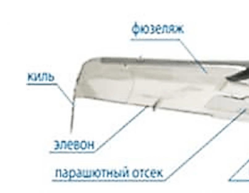
UAV DEVICE
two main UAV layout schemes: classical (according to the “fuselage + wings + tail” scheme), which includes, for example, the Orlan-10 UAV, Mavinci SIRIUS (Fig. 1) and others, and the “flying wing”, which include Geoscan101 (Fig. 2), Gatewing X100, Trimble UX5, etc.
The main parts of an unmanned aerial photography complex are: body, engine, onboard control system (autopilot), ground control system (GCS) and aerial photography equipment.
The body of the UAV is made of lightweight plastic (such as carbon fiber or Kevlar) to protect expensive photographic equipment and controls and navigation, and its wings are made of plastic or extruded polystyrene foam (EPP). This material is light, strong enough and does not break on impact. A deformed EPP part can often be repaired with improvised means.
A light UAV with a parachute landing can withstand several hundred flights without repair, which, as a rule, includes the replacement of wings, fuselage elements, etc. Manufacturers try to reduce the cost of parts of the hull that are subject to wear so that the cost to the user to maintain the UAV in working condition is minimal.
It should be noted that the most expensive elements of the aerial photography complex, the ground control system, avionics, software, are not subject to wear at all.
The power plant of the UAV can be gasoline or electric. Moreover, a gasoline engine will provide a much longer flight, since in gasoline, per kilogram, 10-15 times more energy is stored than can be stored in the very the best battery. However, such a power plant is complex, less reliable and requires a significant amount of time to prepare the UAV for launch. In addition, a gasoline-powered unmanned aerial vehicle is extremely difficult to transport to the job site by plane. Finally, it requires a highly skilled operator. Therefore, it makes sense to use a gasoline-powered UAV only in cases where a very long flight duration is required - for continuous monitoring, for examining particularly remote objects.
The electric propulsion system, on the other hand, is very undemanding to the skill level of the operating personnel. Modern rechargeable batteries can provide a continuous flight duration of more than four hours. Servicing an electric motor is very easy. Mostly this is only protection against moisture and dirt, as well as checking the voltage of the on-board network, which is carried out from the ground control system. The batteries are charged from the on-board network of the accompanying vehicle or from an autonomous power generator. The brushless electric motor of the UAV practically does not wear out.
The autopilot - with an inertial system (Fig. 3) is the most important control element of the UAV.
The autopilot weighs only 20-30 grams. But this is a very complex product. In the autopilot, in addition to a powerful processor, many sensors are installed - a three-axis gyroscope and accelerometer (and sometimes a magnetometer), a GLO-NASS / GPS receiver, a pressure sensor, an airspeed sensor. With these devices, an unmanned aerial vehicle will be able to fly strictly on a given course.

Rice. 3. AutopilotMicropilot
The UAV has a radio modem necessary for downloading a flight task, transferring telemetry data about the flight and the current location at the work site to the ground control system.
Ground control system
(NSU) is a tablet computer or laptop equipped with a modem for communication with the UAV. An important part of the NSU is software for planning a flight task and displaying the progress of its implementation.
As a rule, a flight task is compiled automatically, according to a given contour of an areal object or nodal points of a linear object. In addition, it is possible to design flight routes based on the required flight altitude and the required resolution of photographs on the ground. To automatically maintain a given flight altitude, it is possible to take into account a digital terrain model in common formats in a flight task.
During the flight, the position of the UAV and the contours of the photographs being taken are displayed on the cartographic substrate of the NSU monitor. During the flight, the operator has the ability to quickly redirect the UAV to another landing area and even quickly land the UAV from the "red" button on the ground control system. On command from the NSU, other auxiliary operations can be planned, for example, parachute release.
In addition to providing navigation and flight, the autopilot must control the camera in order to receive images at a given frame interval (as soon as the UAV flies the required distance from the previous photographic center). If the pre-calculated inter-frame interval is not stable, you have to adjust the shutter time so that even with a tailwind, the longitudinal overlap is sufficient.
The autopilot must register the coordinates of the photographing centers of the GLONASS/GPS geodetic satellite receiver so that the automatic image processing program can quickly build a model and bind it to the terrain. The required accuracy in determining the coordinates of the photographing centers depends on terms of reference for aerial photography.
Aerial photography equipment is installed on the UAV depending on its class and purpose of use.
Micro- and mini-UAVs are equipped with compact digital cameras equipped with interchangeable lenses with constant focal length(without zoom or zoom device) weighing 300-500 grams. SONY NEX-7 cameras are currently used as such cameras.
with a 24.3 MP sensor, CANON600D 18.5 MP sensor, and the like. Shutter control and signal transmission from the shutter to the satellite receiver is performed using standard or slightly modified electrical connectors of the camera.
Light short-range UAVs are equipped with SLR cameras with a large photosensitive element, for example, Canon EOS5D (sensor size 36 × 24 mm), Nikon D800 (36.8 MP matrix (sensor size 35.9 × 24 mm)), Pentax645D (CCD sensor 44 × 33 mm, 40 MP matrix) and the like, weighing 1.0–1.5 kilograms.

Rice. 4. Scheme of placement of aerial photographs (blue rectangles with labels of numbers)
UAV CAPABILITIES
According to the requirements of the document "Basic provisions for aerial photography performed to create and update topographic maps and plans" GKINP-09-32-80, the carrier of aerial photography equipment must follow the design position of aerial photography routes as accurately as possible, maintain a given echelon (photographing height), ensure the requirements for compliance limit deviations for camera orientation angles - tilt, roll, pitch. In addition, navigation equipment must provide exact time shutter operation and determine the coordinates of the centers of photography.
The equipment integrated into the autopilot was mentioned above: these are a microbarometer, an airspeed sensor, an inertial system, and satellite navigation equipment. According to the tests carried out (in particular, the Geoscan101 UAV), the following deviations of the real shooting parameters from the given ones were established:
UAV deviations from the route axis - in the range of 5–10 meters;
Deviations of photographing heights - in the range of 5–10 meters;
Height fluctuation of photographing adjacent images - no more
Arising in flight "Christmas trees" (turns of images in the horizontal plane) are processed automated system photogrammetric processing without noticeable negative consequences.
The photographic equipment installed on the UAV makes it possible to obtain digital images of the terrain with a resolution of better than 3 centimeters per pixel. The use of short-, medium-, and long-focus photographic lenses is determined by the nature of the finished materials obtained: be it a relief model or an orthophotomap. All calculations are made in the same way as in the "big" aerial photography.
The use of a dual-frequency GLO-NASS/GPS satellite geodetic system for determining the coordinates of image centers allows, in the process of post-processing, to obtain the coordinates of photographing centers with an accuracy better than 5 centimeters, and the use of the PPP (PrecisePointPositioning) method allows determining the coordinates of image centers without using base stations or at a considerable distance from them.
The final processing of aerial photography materials can serve as an objective criterion for assessing the quality of the work performed. For illustration, we can consider the data on the assessment of the accuracy of photogrammetric processing of aerial photography materials from the UAV, performed in the PhotoScan software (manufactured by Agisoſt, St. Petersburg) by control points (Table 2).
|
Point numbers |
Errors along the coordinate axes, m |
Abs, pix |
projections |
|||
|
(ΔD)2= ΔХ2+ ΔY2+ ΔZ2 |
||||||
UAV APPLICATION
in the world, and in Lately and in Russia, unmanned aerial vehicles are used in geodetic surveys during construction, for drawing up cadastral plans for industrial facilities, transport infrastructure, villages, summer cottages, in mine surveying for determining the volume of mine workings and dumps, taking into account the movement of bulk cargo in quarries, ports, mining and processing plants, to create maps, plans and 3D models of cities and enterprises.
3. Tseplyaeva T.P., Morozova O.V. Stages of development of unmanned aerial vehicles. M., "Open information and computer integrated technologies", No. 42, 2009.
Drones have become more and more popular in recent years. They are beginning to be used everywhere: in the air, on water and on land. Scientists around the world have high hopes for unmanned devices and expect that in the future there will be no area where they will not be used. Today, these devices are one of the most promising directions in the development of military technology. Their use has already led to a significant change in the tactics of warfare.
Significant changes are expected to take place in the civil sector as well. By 2025, the global drone technology market will grow several hundredfold, displacing many existing operational processes. The cost of devices is gradually decreasing, and with their introduction into large-scale production, they will cost very little, which will lead to their widespread use.
Kinds
INair . UAVs are increasingly being used, as it is much easier to control an air drone, because there are practically no obstacles in the air. These are various flying military robots, drones for photo and video filming, entertainment devices, airships, including units delivering goods and parcels.
UAV by purpose:
- Commercial or civil . They are designed for transporting goods, construction, fertilizing fields, scientific research etc.

- Consumer . In most cases, they are used for entertainment, such as racing, shooting high-altitude videos, and so on.

- Combat. They have a complex design, they are used for military purposes.

By design, aerial drones can be of the following types:
- Fixed wing drones . Their advantages include greater range and flight speed.
- Multicopters . They can have a different number of propellers: from 2 to 8. Propellers on some models can be folded.
- Drones helicopter type.
- tiltrotor . The peculiarity of such models is that they take off “by helicopter”, and in flight they move like an airplane, relying on wings.
- Gliders or gliders . These devices can be motorized or non-motorized. In most cases, they are used for reconnaissance operations.
- Tailsitters . The UAV rotates its structure in the vertical plane to change the flight mode.
- exotic . These devices have an atypical design, for example, devices that can land on water, take off from it and dive into it. They can also be devices that land on a vertical surface and can climb on it.
- Tethered drones . Their peculiarity is that the energy is supplied to such a drone through a wire.
- miniature .
- Modular .
Ground drones . Their design is created taking into account the presence of numerous obstacles and objects that may be under the wheels. Also here it is necessary to take into account the type of soil. IN this case military developments have great prospects.

On flat surfaces, the situation is somewhat different. Many companies developing the civilian automotive sector are working in this direction. Current laws restrict the use of such devices. But today there are already certain advances that will allow introducing these cars in the coming years.
Water drones. These are tankers, submarines, robo-fish and so on. Inventors are constantly improving devices, creating robotic water striders, jellyfish, and fish.

Space drones. Their peculiarity is that they are incredibly complex and accurate devices that do not tolerate mistakes. A lot of money is allocated for their production, but mostly single copies are created.
Device
Unmanned aerial vehicles in most cases consist of the following main elements:
- Screw speed control device.
- Propeller.
- Engine.
- flight controller.
- Frame.
The basis of the flying machine is the frame. It is on it that all the elements are installed. In most cases, it is made from polymers and various metal alloys. The flight controller controls the drone. It receives signals from the control panel. The controller includes a processor, a barometer, which determines the height, an accelerometer, a gyroscope, a GPS navigator, a random access memory, a signal receiving device.
The motors, governors and propellers are responsible for the flight of the drone. The controller controls the speed of the aircraft. The battery is the source of energy for the motor, as well as other elements of the drone. Commercial and consumer drones are controlled by a remote control. Military units are controlled both by remote control and satellite systems.
The device of ground-based drones is somewhat different from flying ones. Most developers use existing vehicles into which it embeds controls, cameras, sensors, and sensors. According to the degree of automation, these can be completely autonomous devices or units that are controlled partially or completely by a person, but at a distance. Military ground drones can range from miniature as worms and snakes to huge as tanks, mine-clearing, amphibious and infantry vehicles.
The device of civilian vehicles is made taking into account the following elements:
- Laser, sound, infrared and other sensors.
- Navigation that combines electronic maps and a GPS system.
- Server with batteries and software.
- Automated controls, which include the engine control system, steering, brake system.
- Transmission.
- A wireless network through which control can take place, programs, maps and other data can be downloaded.
Operating principle
Commercial and consumer drones are in most cases controlled by a remote control. However, there may be fully automatic devices. Remote controller remote control sends signals to the controller.
The controller processes the received signals and then sends commands to various elements of the drone. For example, an increase in speed signal causes the propeller to spin faster, which leads to an increase in the speed and movement of the drone.
Fully automated ground vehicles lack the typical controls found in standard vehicles. There are no pedals, no steering wheel. The passenger only needs to activate, that is, indicate the destination where he needs to go, or deactivate the system.
Unmanned vehicles usually have a variety of sensors and sensors that help them navigate in space. Their basis, for example, can be a 64-beam light rangefinder, which is installed on the roof of the car. With the help of this device, a detailed map of the space around the car is generated. Next, the car combines the received information with high-precision maps and processes them.
As a result, he can move around avoiding any obstacles that arise. There are also other sensors and devices on the car, including bumper radars, front and rear view cameras, inertial meters, wheel sensors, which allow you to determine the position and track the movement of the car.
Application

- Civilian are used in industry, agriculture, security and logistics operations.
- Systems using drones and special software can autonomously explore the required area, creating two or three-dimensional maps. In addition, they can receive visual data that will help builders and architects make the right decisions in construction, power supply, and so on.
- Taxi and air taxi without a driver. A person only needs to call a taxi on his gadget so that it comes to him and delivers him to the required place. At the moment, such opportunities are only being tested, but in the future, this is the way the majority of citizens will move about their business.
- Unmanned aerial vehicles open up huge opportunities for the military. It is no longer necessary to risk the lives of people to complete the task. Military equipment can be controlled by an operator thousands of miles from the scene of action. Tanks and aircraft may even become fully automated. It will be enough for them to download the program so that they complete the task. Drones have already appeared today that can fire missiles and drop bombs.

The military is also creating smaller devices in the form of insects, worms and snakes. They can be used discreetly for reconnaissance and even to destroy targets. For example, a drone in the form of a wasp can attack an enemy, piercing them with a stinger and releasing a deadly poison.
- Unmanned vehicles can be used to deliver goods, pizza, mail or medicines.
- UAVs help fight poachers, detect fires and landfills, plant forests, inspect clearings, keep a record of animals in the herd.